Thursday, June 09, 2005


Snapper over looking a pipestone quarry. The deep red rock at the bottom of the pit is the pipestone. Posted by Hello

This was the Visitor Center's in house pipestone pipe maker work area. Posted by Hello

This is Bill Bryant, the Visitor Center in house pipestone pipe maker. We just happened to cross paths while he was on his way home after getting off of work. He looked like a real indian to me. Posted by Hello

Pipestone, MN is a place that has a pipestone rock quarry. Back in the old days, indians would make smoking pipes and other things out of the pipestone. Posted by Hello

NorthField, Minnesota - two day after leaving Pennsylvania

Eastern Minnesota was much like western Wisconsin, in that it was very beautiful. It was filled with rolling hills and winding roads working their way through beautiful farm land. My first major stop in Minnesota was the quiet little town of Northfield.

Why Northfield you ask? Most people never even heard of Northfield MN. But if you're into history like some folks, then you'll know that Northfield is a place of significance. Northfield, MN is where the James and Younger gang attempted and fail to rob the First National Bank. It was their first and only unsuccessful bank robbery attempt.

The town, itself, is a quiet little town just like any other mid-western little town. I liked the place, but I remember the winters and there didn't seem like there was too much to do, so I left.

I'm outta here...I'm heading for The Black Hills National Park in South Dakota.

This is the inside of the Northfield bank. It looks basically the same as it did back in Sept. 7, 1876. You can see the vault in the background. Posted by Hello

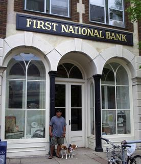
Me and the pups in front of the very bank in Northfield, Minnesota that the James and Younger gang attempted to rob back in 1876. The bank is a museum now, and unfortunately, it was close when I got there. The bank bascially looks the same way it did back then. Posted by Hello

The pups on the Minnesota side of the mighty Mississippi River. In the background, are locks and dam. Posted by Hello

Going from Pennsylvania to Minnesota

After leaving Gettysburg PA, I headed west to Indian country. I wanted to visit some historical Indian site in Ohio and Indiana, but I wasn't able to find any. So, I literally drove straight through to Minnesota from Pennsylvania. Between Gettysburg and Chicago, I had to pay a toll fee on those turnpikes. That SUCKED! Because it wasn't cheap. I couldn't wait until I got to Wisconsin and Minnesota. What the heck is a turnpike?

Western Wisconsin was extremely beautiful. If it weren't for the burtally long winters, I think I might want to live there, especially in Madsion. Madison, WI is a totally cool place.

Gettysburg National Battlefield, Gettysburg PA - Two days after Memorial Day

Antietam National Battlefield the day before was truly an experience, but Gettysburg National Battlefield gave me a dose of the same, and then some. Gettysburg National Battlefield is considered to be the grand daddy of all the National Battlefields of the Civil War. Even it's Visitor Center was larger than any of the other National Battlefields I had previously visited, with it's two levels filled with thousands of artifacts, and Cyclorama Building. The Cyclorama Building is a three-level structure that has a lookout deck where you can see every part of the battlefield. The Visitor Center is located on Cemetary Ridge a few hundred yards from the infamous "Angle" directly in front of the original Gettysburg Cemetary on Cemetary Ridge.

To see the whole battlefield takes a whole day. Like most of the other National Battlefields, you tour the site by automobile, starting out and finishing the tour at the Visitor Center. And believe me, even though you're in a car most of the time, by the end of the tour, you are extremely exhausted and very hungry.

Like Harpers Ferry, there were thousands of people everywhere, especially at Little Roundtop and Devil's Den. Still, because of the massiveness of the battlefield, there were many occasions where I found myself all alone. Little Roundtop and the "Angle" were definitely the coolest places on the whole battlefield. At Little Roundtop, me and the dogs were able to climb around on the rocks and hike through the dense woods.

The "Angle" was definitely one of the coolest part of the day. From its location, you can clearly see the starting point where Picket's Charge began on Seminary Ridge some 500 yards away from Cemetary Ridge. When you come to this spot, you will really come to understand the kind of courage those men had back on that hot summer day of July 3, 1863.

The town of Gettysburg is a cool place. It's a very small peaceful town. The thing I didn't understand was that you can't buy beer at the local corner store. No, one has to go to a "Beer" store to buy beer. I drove all over Gettysburg looking for one of those so called "Beer" store and never found one. Instead, I found a micro-brewery call The Appalachian Brewery Company (ABC). And lucky for me, they sold beer by the bottle. That whole ordeal worked out great, because micro-brewery beer, is way better than Coor's Lite in a bottle any day. Well, almost...maybe...

John! If you're reading this, I save a bottle of ABC for you.

Wednesday, June 08, 2005


Seminary Ridge viewed from Cemetary Ridge. It is from Seminary Ridge where Picket made his famous charge from. The tree on the left is the infamous "angle" where Armstead's men penetrated the Union line. Posted by Hello

Me and the gang on top of Devil's Den, Gettysburg National battlefield. Posted by Hello

Me with twins on Little Roundtop. The pups are such magnets... Posted by Hello

Re-inactors Posted by Hello

Me and the gang in front of the Northern Virginia Monument on Seminary Ridge. This also is where Lee's HQ and center was positioned at. Posted by Hello

The view of both Little and Big Roundtop off in the distance (center) from the Confederate position on Seminary Ridge to the right of the picture. Posted by Hello

Like at Antietam, hundreds of memorials like this one literally litter the Gettysburg battlefield. Posted by Hello

This is the spot where Union Corp General Renyolds fell on the first day as the rebels were approaching Gettysburg from the north west on the road on the right of the picture. Posted by Hello

This monument marks the spot where Lincoln gave his famous Gettysburg Address, Gettysburg Cemetary, Gettysburg PA Posted by Hello

General Meade's battle flag, Visitor Center, Gettysburg National Battlefield, Gettysburg PA. Posted by Hello

Antietam National Battlefield, Shargsburg MD. The day after Memorial Day.

The drive up from Harpers Ferry to Shargsburg was quick and easy. It was a mere twenty minutes, but it was twenty minutes filled with more winding roads carving through rolling hills on a beautiful warm sunny afternoon.

Unlike Harpers Ferry, Antietam National Battlefield lacked the loud sounds of kids running everywhere. There were a few people there, but much more, then there were at the Chancellorsville, The Wilderness, and Sportsylvania Battlefields combined. Then again, the weather wasn't as nasty and wet like it was then either.

It took every bit of the afternoon to tour and see the whole battlefield. Like most of the major Civil War battlefields, it was spread out for miles. So, a car is the transportation of choice. Still, I think the best way to see the entire battlefield is by bike. At least, when the weather is pleasant and prefect like it was on this day.

The place seemed timeless. Not much has changed since the Civil War. The Dunken Church was still there, as well as most of the farms, and Burnside Bridge. There were scores of monuments and memorials everywhere. There were artillery batteries at numerous locations exactly where they had been placed during the time of the battle.

It was a very moving experience, as I went to all the various parts of the battlefield. The cornfield, the Sunden Rd, and Burnside Bridge. I was taken back into time to that horrible day. I could hear the sounds of men running and falling as mini balls shread their way through the cornstocks in the cornfield. The claddering and popping of thousand union rifle muskets countinously firing on the rebs in the Sunken Rd until they were either all dead or had routed.

It's hard for anyone to walk away from the battlefield without feeling so sad for the thousands of men who paid the ultimate price for such a stupid cause.

Burnside Bridge viewed from the rebel side. This was Lee's right flank. On the afternoon of the battle, hundreds of Union soldiers fell trying to take this bridge. The Union did manage to take the bridge. It looks much as it did then. Posted by Hello

Burnsides Bridge over Antietam Creek viewed from the Union side. Posted by Hello

The infamous Sunken Rd. Commonly known as "Bloody Lane". This was Lee's center. Hundreds of confederate soldiers died here before it was over ran by the Union. The bodies were piled high in a sea of blood. Posted by Hello

The infamous corn field where the Union attempted to break Lee's left flank at dawn on Sept 17, 1862. For three hours, waves of men from both sides fought and fell. It looks much the same as it did then. Posted by Hello

Comet relaxing at the Visitor Center and looking out towards the Sunken Rd "Bloody Lane", the center of Lee's line, Antietam National Battlefield, MD. Posted by Hello

A Union Memorial right next to the Visitor Center at the Antietam National Battlefield in Sharpsburg MD. There were memorials as well as monuments scatter thoughout the battlefield. Posted by Hello

The Day After Memorial Day, Harpers Ferry VA

After 5 great days spent in DC and Mannassas, I went to Harpers Ferry VA. I hadn't intend on going there originally, but when I learned that it was on the way to the Antietam National Battlefield, I figured why not stop by and check it out.

After all, this the place where Mr "Fire n Brimstone" John Brown made his infamous futal attempt to rob the armory there just before the beginning of the American Civil War.

The route I took to Harpers Ferry from Mannassas, took me through some the most beautiful farm country I have ever seen. It was a beautiful warm sunny day as I drove down the winding roads and rolling hills of Northern Virginia. One couldn't have asked for a better day.

When I arrived at Harpers Ferry, I discovered that it was a little town that's located where the Potomac River and the Shenandoah River meet. Much to my surprise, it was great place. It was rich with history dating as far back as "Lewis and Clark".

The town was on a steep side of a hill, and much of the building looked much the same as they did back then. There were tourist by the scores. Lots of highschool kids running and screaming from every direction. Snapper and Comet got tons of attention. There was an old canal system that no longer held water. There was a train trestle that spanned the Potomac River, and one that had been washed away by a hundred year flood.

Next, it's on to Sharpsburg MA to visit the Antietam National Battlefield. Going to this place has been a life long dream of mind, and I was only 20 minutes away from it. Hallow grounds, here I go...

Harpers Ferry is one of those rare places where the town is part of a historical park. Two-thirds of the town structures are historical landmark, and look much the same as they did during the Civil War. Posted by Hello

This is the building that John Brown was held up in during his failed attempt to take the armory at Harpers Ferry in Northern Virginia. Posted by Hello

Finally back online after more than a week and 8 states later

Wow! It seems like forever since the last time I was online. I'm now in a coffee shop in Rapid City SD, call "DunnBros Coffee House" trying to get caught up on my blogg stuff. It's a cool place with free WiFi and lots of hot looking chicks all around me. So, if you find a lot of typos my writing today, it's because I'm having a hard time concentrating.